
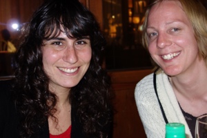
Last night’s dinner companions, Alissa and Rita
After a night of deep, Ambien assisted sleep and breakfast at the hotel I was ready to go at 7:30 this morning for our trip to Copacabana, a resort town on the Bolivian shores of Lake Titicaca. Alissa lined up a tour, so we were picked up Angelo, our guide, and Domingo the driver in his van.
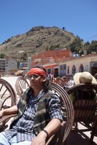
Angelo at lunch, later in the day
We exited La Paz by climbing the old road to El Alto, the rapidly expanding suburban area of the city on the altiplano, or high plains, where the airport is. Traffic was quite busy and Domingo threaded us through trucks, cars, busses, minivans, potholes, dirt roads and pavement with some skill. A side note about traffic in La Paz–cars go every which way, and have the absolute right of the road (As a pedestrian you are totally responsible for your own safety). The primary mode of public transit are 15-20 passenger vans that service neighborhoods and run on more or less formal routes, but less formal schedules. There are designated pickup spots all over the city, and the vans will go by with the conductor(?) leaning out the open sliding door calling out the destination at the top of his lungs. When someone flags him the van just stops, maybe on the side of the road but usually pretty much where he is, causing traffic to flow past however it can, and entitling the passenger to dodge that traffic in order to make his way to his ride.
Once we got to the plateau, El Alto went on forever. There is a construction boom; the population of La Paz has increased massively over the past twenty to thirty years, and a lot of is concentrated there. Housing, commercial, industrial, roads, it all was going on. Many unfinished structures, as taxes are collected only on completed ones. The government is paving roads as fast as they can, but have extended electrical service throughout. The national focus really is on development for all the people, not for the oligarchy and it seems that the government is quite committed to that goal. Its really reflected in Alissa’s work, which maybe I can get her to post about. Hooray for Evo (Morales, president of Bolivia). Everyone calls him Evo.
It took about an hour to get out on the open road, where we paralleled a string of high, snow capped mountains to our right and wide open plains dotted with small shacks probably herders shelters, to our left. Our first view of Lake Titicaca came after another hour or so of driving, shallow wetlands giving no real hint of the size and drama of the full lake. We made a brief stop at the home and workshop of one of the last reed boat makers in the world, who built the Ra II for Thor Heyerdal, then continued on to Tiquino, where a short ferry ride took us across the inlet to the peninsula on which Copacabana is located. The flat bottom vehicle ferries carry one or two vehicles at a time, trucks, busses, cars, and are dangerous enough that passengers disembark and use standard boats to make the trip even though it’s only five minutes long.
ferries
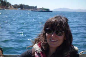
Alissa on Ferry with commerce proceeding in the background
Another hour on the road brought us to Copacabana, a small town which fronts a nice beach on the lake and evidently is jam packed every weekend; today, a Tuesday, foreign tourists were the only ones to be seen.
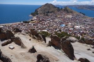
Copacabana. Beach to left; cathedral complex in center right.
After checking in to our hotel our first order of business was lunch by the lake. Trout were introduced here in the 1930’s to provide a better source of protein for the locals, and have been spectacularly successful, as every menu I’ve seen in Bolivia can testify. Today’s had 15 different preparations.
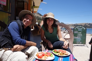
on the left, trout with red pepper sauce; on the right in a white wine reduction
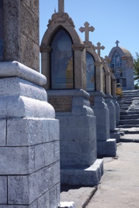
After lunch it was off to the Moorish cathedral in the center of town, totally out of scale to the rest of the place; started in 1671, it took nearly 100 years to complete. There is a festival of the virgin here twice a year. There is another important religious site which you can see at the top of the hill in the photo above, the Sanctuario del Calvario, a very steep hike on which the stations of the cross are set, leading to an outdoor cathedral on the top of the hill that is used a lot for various observances. I don’t use the word steep lightly. We all were huffing and puffing, even Angelo, a local, and Alissa, who has been running on a treadmill at the gym every day. And it was only (!) 12,600 ft. at the top. Made me worry about next week, but Alissa assured me that I wasn’t fully acclimated yet. OK. . . (Actually, though, everyone I met here was very impressed that I got off the plane from sea level yesterday morning and spent seven hours walking around town, showing no effects at all from the altitude. Today reminded me to continue to take it seriously.)
Outdoor cathedral
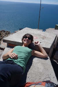
Alissa recovering from the climb
We visited one other site, before the Sanctuario, a pre-Inca observatory up an equally steep hill on the other side of town. Angelo didn’t know much about the science of it, and it wasn’t listed in my guidebook, but the ancient stairway survives as does the construction itself, on a hill filled with the knifelike ridges you can see defining the sides of the construction.
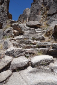
Ancient stairs navigating the equally steep hill.
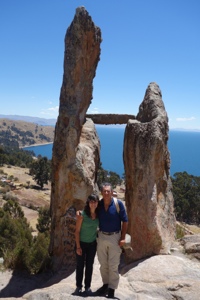
post-Inca gringos at the pre Inca observatory.
We stumbled back down the hill and installed ourselves at La Cupula, a charming little hotel that itself is about 200 feet above town. A nap, a shower, dinner at the hotel tonight and tomorrow we are on a day trip to the Isla Del Sol, in the middle of the lake, site of the Inca creation myth, and back to La Paz tomorrow night.
Thanks for reading.